<<< Back to Lake Erie Habitat-Project Inventory HOME Page
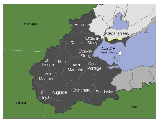
Click on a region of the map or a link below to view a spatial inventory of projects in that region.
By Watershed:
Auglaize - Blanchard - Cedar Creek -Cedar-Portage - Huron - Lower Maumee - Ottawa-Stony - Raisin - St. Joseph - St. Mary’s - Sandusky - Tiffin - Upper Maumee
By Waterbody:
By Watershed
No
habitat-related projects currently recorded.
^^back
to top
No habitat-related projects
currently recorded.
^^back
to top
No habitat-related projects
currently recorded.
^^back
to top
|
|
Project Title |
Project Type |
Watershed(s) |
Waterbody(ies) |
Location |
Status |
Lead
Agency / |
Variables Measured |
Documents |
Contact |
Links |
|
1 |
|
Rehabilitation Projects: Implementing strategies, engineering studies |
Cedar-Portage,
|
n/a |
Ottawa
Co., |
Delayed pending result of ODNR appeal to USCOE (original permit denied). |
ODNR, Div.
of Wildlife, Div. of State Parks / ODNR, Friends of |
Depth, substrate, and turbidity; fish communities |
|
Eric
Weimer, |
|
|
Description:
Project to restore nearshore coastal fish community to |
|||||||||||
|
|
Project Title |
Project Type |
Watershed(s) |
Waterbody(ies) |
Location |
Status |
Lead
Agency / |
Variables Measured |
Documents |
Contact |
Links |
|
1 |
Huron River Watershed Assessment |
Projects involving monitoring and evaluation of habitat |
Huron |
n/a |
Tributary to western Lake Erie |
Completed |
MDNR |
|
|
J. Baunscheidel; MDNR-Fisheries; 248-359-9048 |
|
|
Description: Assessment of landscapes, fisheries, and aquatic habitats in the river's watershed providing a comprehensive reference for all resource management applications. |
|
||||||||||
|
|
Project Title |
Project Type |
Watershed(s) |
Waterbody(ies) |
Location |
Status |
Lead
Agency / |
Variables Measured |
Documents |
Contact |
Links |
|
1 |
Dredge Sediment Plume Characterization Study |
Projects involving monitoring and evaluation of habitat |
Lower Maumee, Upper Maumee |
n/a |
Maumee Bay, Ohio |
Summer 2004, results/completion report summer 2006 |
US Army Corps of Engineers, Ohio Division of Wildlife |
|
|
|
|
|
Description: Characterization of spatial extent of suspended sediment plumes as they relate to dredging operations in and around Maumee Bay using Acoustic Doppler Current Profiler and turbidity meters. |
|||||||||||
|
2 |
Maumee River AOC |
Rehabilitation Projects: Implementing strategies, engineering studies |
Lower Maumee, Upper Maumee |
n/a |
Maumee River, OH |
Ongoing |
OHEPA: RAP co-ordinator / Extensive list of government, industry and NGO, see website |
|
|
|
|
|
Description: Ongoing rehab via implementation of RAP (stage 2): details [http://www.epa.gov/glnpo/aoc/maumee.html] |
|
||||||||||
|
3 |
Maumee Bay Habitat Restoration Unit |
Rehabilitation Projects: Implementing strategies, engineering studies |
Lower Maumee, Upper Maumee |
n/a |
Maumee Bay and nearby nearshore areas and or south shore marshes of the western basin, Ohio |
Ongoing - information from Middle Harbor experiment will be further developed for this project |
Ohio Division of Wildlife / Army Corps of Engineers, ODNR, USFWS, Toledo Port Authority, Lake Erie Charter Boat Association |
Sediment (Ponar grabs and side scan imagery) |
|
J. Tyson, Sandusky Fish Research Unit, ODNR, 305 E. Shoreline Dr. Sandusky, Ohio 44 |
|
|
Description: Examining the beneficial reuse of dredge materials for physical habitat restoration. Potential for restoration of degraded sites – such as dredge disposal sites, or use to soften wave energy in nearshore areas. |
|||||||||||
No habitat-related projects
currently recorded.
^^back
to top
|
|
Project Title |
Project Type |
Watershed(s) |
Waterbody(ies) |
Location |
Status |
Lead Agency
/ |
Variables Measured |
Documents |
Contact |
Links |
|
1 |
Raisin River Watershed Assessment |
Projects involving monitoring and evaluation of habitat |
Raisin |
n/a |
Tributary to western Lake Erie |
Completed |
MDNR |
|
|
J. Baunscheidel; MDNR-Fisheries; 248-359-9048 |
|
|
Description: Assessment of landscapes, fisheries, and aquatic habitats in the river's watershed providing a comprehensive reference for all resource management applications. |
|
||||||||||
No habitat-related projects
currently recorded.
^^back
to top
No habitat-related projects
currently recorded.
^^back
to top
|
|
Project Title |
Project Type |
Watershed(s) |
Waterbody(ies) |
Location |
Status |
Lead
Agency / |
Variables Measured |
Documents |
Contact |
Links |
|
1 |
Sandusky River/Bay walleye movement and spawning habitat study |
Projects involving monitoring and evaluation of habitat |
Sandusky |
Lake Erie |
Sandusky River/Bay |
Ongoing 2006-2008 |
ODNR, Div. of Wildlife / Ohio State University |
|
|
E. Weimer, Sandusky Fish Research Unit, ODNR, 305 E. Shoreline Dr. Sandusky, Ohio 44 |
|
|
Description: Sandusky River/Bay spawning stock movement will be monitored during spawning to determine, among other things, location and use of available spawning habitat within the bay and river. |
|
||||||||||
|
2 |
Coupling Ecological, Economic and Engineering Studies to Formulate Guidelines for Dam Removal and River Restoration in the Great Lakes. |
Projects involving monitoring and evaluation of habitat |
Sandusky |
n/a |
Sandusky River, Ohio |
Spring 2003-2006; Completed (Reference #3) |
Ohio State University / ODNR |
|
|
T. Granata, 417C Hitchcock, 2070 Neil Avenue, Columbus, Oh 43210 |
|
|
Description: Development of general guidelines and modeling tools to assess the ecological, hydraulic, and economic impacts of dam removals and management options within the Great Lakes. This work has also entailed additions of spawning substrate below the Ballville Dam (Sandusky River) to monitor response of walleye spawning. |
|
||||||||||
|
3 |
Ohio Barrier/Access Project: Ballville Dam |
Rehabilitation Projects: Implementing strategies, engineering studies |
Sandusky |
n/a |
Sandusky Co., Ohio; Freemont |
Ongoing; dam removal feasibility study being considered |
Ohio Div. of Wildlife, USFWS, ODNR, USACE, Ohio Div. of Water |
Sediment (Ponar grabs) |
|
E. Weimer, Sandusky Fish Research Unit, ODNR, 305 E. Shoreline Dr. Sandusky, Ohio 44 |
|
|
Description: Ballville Dam on Sandusky River blocks upstream walleye migration and starves existing spawning habitat of gravel/cobble renourishment. |
|||||||||||
No habitat-related projects
currently recorded.
^^back
to top
|
|
Project Title |
Project Type |
Watershed(s) |
Waterbody(ies) |
Location |
Status |
Lead
Agency / |
Variables Measured |
Documents |
Contact |
Links |
|
1 |
Dredge Sediment Plume Characterization Study |
Projects involving monitoring and evaluation of habitat |
Lower Maumee, Upper Maumee |
n/a |
Maumee Bay, Ohio |
Summer 2004, results/completion report summer 2006 |
US Army Corps of Engineers, Ohio Division of Wildlife |
|
|
|
|
|
Description: Characterization of spatial extent of suspended sediment plumes as they relate to dredging operations in and around Maumee Bay using Acoustic Doppler Current Profiler and turbidity meters. |
|||||||||||
|
2 |
Maumee River AOC |
Rehabilitation Projects: Implementing strategies, engineering studies |
Lower Maumee, Upper Maumee |
n/a |
Maumee River, OH |
Ongoing |
OHEPA: RAP co-ordinator / Extensive list of government, industry and NGO, see website |
|
|
|
|
|
Description: Ongoing rehab via implementation of RAP (stage 2): details [http://www.epa.gov/glnpo/aoc/maumee.html] |
|
||||||||||
|
3 |
Maumee Bay Habitat Restoration Unit |
Rehabilitation Projects: Implementing strategies, engineering studies |
Lower Maumee, Upper Maumee |
n/a |
Maumee Bay and nearby nearshore areas and or south shore marshes of the western basin, Ohio |
Ongoing - information from Middle Harbor experiment will be further developed for this project |
Ohio Division of Wildlife / Army Corps of Engineers, ODNR, USFWS, Toledo Port Authority, Lake Erie Charter Boat Association |
Sediment (Ponar grabs and side scan imagery) |
|
J. Tyson, Sandusky Fish Research Unit, ODNR, 305 E. Shoreline Dr. Sandusky, Ohio 44 |
|
|
Description: Examining the beneficial reuse of dredge materials for physical habitat restoration. Potential for restoration of degraded sites – such as dredge disposal sites, or use to soften wave energy in nearshore areas. |
|||||||||||
By Waterbody
|
|
Project Title |
Project Type |
Watershed(s) |
Waterbody(ies) |
Location |
Status |
Lead Agency / Partners |
Variables Measured |
Documents |
Contact |
Links |
|
1 |
Sandusky River/Bay walleye movement and spawning habitat study |
Projects involving monitoring and evaluation of habitat |
Sandusky |
Lake Erie |
Sandusky River/Bay |
Ongoing 2006-2008 |
ODNR, Div. of Wildlife / Ohio State University |
|
|
E. Weimer, Sandusky Fish Research Unit, ODNR, 305 E. Shoreline Dr. Sandusky, Ohio 44 |
|
|
Description: Sandusky River/Bay spawning stock movement will be monitored during spawning to determine, among other things, location and use of available spawning habitat within the bay and river. |
|
||||||||||