<<< Back to Lake Erie Habitat-Project Inventory HOME Page
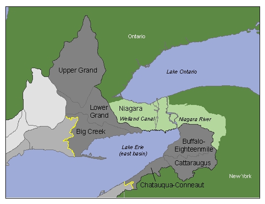
Click on a region of the map or a link below to view a spatial inventory of projects in that region.
By Watershed:
Big Creek - Buffalo-Eighteenmile - Cattaraugus - Chautauqua-Conneaut - Lower Grand - Niagara - Upper Grand
By Waterbody:
By Watershed
|
|
Project Title |
Project Type |
Watershed(s) |
Waterbody(ies) |
Location |
Status |
Lead Agency/ Partners |
Variables Measured |
Documents |
Contact |
Links |
|
1 |
|
Projects involving monitoring and evaluation of habitat |
Big Creek, Lower Grand |
n/a |
|
April 2000 - Dec 2004. Reporting completed in 2005 |
OMNR (LEMU) / EC, OCFA, OFAH |
|
Reference #1 |
Kurt
Oldenburg, |
|
|
Description:
A component of a 5-yr fisheries management plan that involves fisheries and
habitat surveys in the nearshore waters and lower section of tributaries in
the |
|||||||||||
|
2 |
|
Projects involving monitoring and evaluation of habitat |
Big Creek |
n/a |
Lake Erie Eastern Basin North shore |
Pending Funding; Spring and Summer 2007- 2009 |
OMNR (LEMU) |
Temperature (associated with fish catches and long term logging), Dissolved oxygen, Nutrients, Plant coverage, Biotic indices (benthic invertebrates, fish) |
|
Janice
Gilbert or Kurt Oldenburg; |
|
|
Description: To assess the status of the coastal wetland complex located within Long Point. Analysis parameters will include: water and sediment quality, vegetation diversity and richness, aquatic invertebrate diversity and IBI scores, fish, marsh bird and amphibian diversity, tributary water quality and landuse impacts. The results of this study will be used to guide stewardship within the immediate area. |
|||||||||||
|
|
Project Title |
Project Type |
Watershed(s) |
Waterbody(ies) |
Location |
Status |
Lead Agency/ Partners |
Variables
|
Documents |
Contact |
Links |
|
1 |
Buffalo River Walleye introductions |
Rehabilitation Projects: Implementing strategies, engineering studies |
Buffalo-Eighteenmile |
n/a |
Buffalo R., NY |
Spring 2004 |
NYSDEC / Southtowns Walleye Association, Erie County Fish Advisory Board |
|
|
J. Markham, Lake Erie Fisheries Unit – NYSDEC, Dunkirk, NY 14048-1031 |
|
|
Description: Stocking of walleye fingerlings in the Buffalo River in an attempt to establish a breeding walleye population . Project will also monitor water quality and thermal profiles, and evaluate the overall habitat for possible future improvements. |
|||||||||||
|
|
Project Title |
Project Type |
Watershed(s) |
Waterbody(ies) |
Location |
Status |
Lead Agency/ Partners |
Variables Measured |
Documents |
Contact |
Links |
|
1 |
Spooner Ck. Rehabilitation Project |
Rehabilitation Projects: Implementing strategies, engineering studies |
Cattaraugus |
n/a |
Spooner Creek, Tributary of Cattaraugus Creek, NY |
Spring 2003 - Ongoing |
NYSDEC / Western NY Chapter of TU |
|
|
J. Markham, Lake Erie Fisheries Unit – NYSDEC, Dunkirk, NY 14048-1031 |
|
|
Description: Bank stabilization project to minimize erosion, stabilize the creekbed, and improve instream habitat and cover. The project mainly involves tree plantings, but may also include the construction of cribs on high erosion areas. |
|||||||||||
|
2 |
Cattaraugus Creek Migratory Access Improvement |
Rehabilitation Projects: Implementing strategies, engineering studies |
Cattaraugus |
n/a |
Cattaraugus Creek, NY |
2005 to completion |
US Army Corp of Engineers, Erie County / NYSDEC |
|
|
J. Markham, Lake Erie Fisheries Unit – NYSDEC, Dunkirk, NY 14048-1031 |
|
|
Description: This is the initial phase of an investigations into feasibility, costs, and benefits associated with fish passage and sea lamprey attraction /traps at a dam in Springwille, NY on Cattaraugus Ck. Results of this initial study will determine future direction of this project. |
|||||||||||
No habitat-related projects
currently recorded.
^^back
to top
|
|
Project Title |
Project Type |
Watershed(s) |
Waterbody(ies) |
Location |
Status |
Lead Agency/ Partners |
Variables Measured |
Documents |
Contact |
Links |
|
1 |
East Basin Rehabilitation Plan: Habitat component |
Projects involving monitoring and evaluation of habitat |
Big Creek, Lower Grand |
n/a |
North Shore of Eastern Basin |
April 2000 - Dec 2004. Reporting completed in 2005 |
OMNR (LEMU) / EC, OCFA, OFAH |
Lake nearshore and tributary mouths - surface and bottom temperature associated with fish catches. |
Reference #1 |
Kurt Oldenburg, OMNR Lake Erie Management Unit, P.O. Box 429 Port Dover, ON, N0A 1N0 |
|
|
Description: A component of a 5-yr fisheries management plan that involves fisheries and habitat surveys in the nearshore waters and lower section of tributaries in the Ontario waters of the eastern basin from Long Point to the Niagara River. The intent of this component is to link key species (yellow perch and walleye) and the fish community with habitat types in order to identify sites with potential for habitat rehabilitation. |
|||||||||||
|
2 |
Grand River Ecosystem Multi-Partner Initiative for Assessment, Monitoring and Rehabilitation |
Projects involving monitoring and evaluation of habitat |
Upper Grand, Lower Grand |
n/a |
Grand River, Ontario (eastern basin) |
Fieldwork complete. Review of 2000-2005 assessment underway. 2007: Agency and stakeholder workshops and development of habitat rehabilitation strategy |
OMNR (LEMU) (Assessment) and EC (LE LaMP Strategy) / GRCA, MOE, EC, DFO, OFAH |
River Temperatures i) associated with fish catches, ii) bi-weekly water column profiles (also DO and light profiles), iii) bottom long term logging also DO). Water chemistry (bi-weekly). Biotic habitat indices (fish and benthic invertebrate) |
i) "State of the Southern Grand River"; Summer 2007. ii) Completion Reports (water quality, fish community);spring 2007; iii) walleye habitat; Reference #3 |
T. MacDougall, OMNR Lake Erie Management Unit, P.O. Box 429 Port Dover, ON, N0A 1N0 |
|
|
Description: Field work and reporting of fisheries and aquatic habitat concerns in the Grand River, towards the development of a strategy for ecosystem rehabilitation. Including: 1) Water quality 2) Fish migration & habitat use and refuges 3) Fish community IBI and SAR reporting and 4) evaluation of fishway performance to restore natural reproduction of walleye stock. Contributing to “State of” Reporting and the refining of rehabilitation targets and recommendations for reaching them (stream rehab, WPCP operation and reservoir discharge management). |
|||||||||||
|
3 |
Evaluation of Southern Grand River wetlands between Cayuga and Dunnville |
Projects involving monitoring and evaluation of habitat |
Lower Grand |
n/a |
Bottom 42km of Grand River, Ontario |
2004. Final Reporting Complete 2005 |
OMNR (LEMU) / EC |
Temperature, Dissolved oxygen, Nutrients, Plant coverage, Biotic indices (benthic invertebrates) |
Reference #4 |
Janice Gilbert or Kurt Oldenburg; OMNR Lake Erie Management Unit, P.O. Box 429 Port Dover, ON, N0A 1N0 |
|
|
Description: Ten wetlands were evaluated in the summer of 2004 for water and sediment quality along with vegetation and aquatic invertebrate and fish diversity and richness. Surveys were also conducted to determine wetland and river basin bathymetry elevations tied to geodetic benchmarks to assess potential impacts due to a Dunnville Dam removal scenario. |
|||||||||||
|
4 |
Grand River (Fairchilds Creek) Stewardship Initiative |
Rehabilitation Projects: Implementing strategies, engineering studies |
Lower Grand |
n/a |
Grand River, Ontario (eastern basin) |
Ongoing |
OMNR (Brant Stewardship Council) / EC, DFO, GRCA, MOE |
|
|
D. Depuydt, OMNR, 353 Talbot St., W. Aylmer, Ont. N5H 2S8 |
|
|
Description: Stewardship initiatives in Brant and Haldimand Counties to implement “Best Management Practices for agricultural land. Includes the monitoring of baseline and anticipated temporal improvements in water quality (esp. P, N, and TSS) as land use practices change in the watershed. Initial focus will be on the subwatershed of Fairchilds Creek., other areas getting attention as impacts are better understood. |
|||||||||||
|
5 |
Grand River Wetlands: Process Wetland Feasibility Study |
Rehabilitation Projects: Implementing strategies, engineering studies |
Lower Grand |
n/a |
Grand River, Ontario (eastern basin) |
Assessment Complete; Working group established 2006; Ongoing |
OMNR (LEMU) / 6-Nations Ecocentre, MOE, Haldimand-Norfolk Stewardship council, EC |
|
Reference #12 |
Janice Gilbert or Kurt Oldenburg; OMNR Lake Erie Management Unit, P.O. Box 429 Port Dover, ON, N0A 1N0 |
|
|
Description: A study is currently taking place to assess the feasibility of using treatment wetlands to polish WPCP effluent from the Brantford, Caledonia, Cayuga and Dunnville plants. This study will address the current loading rates of nutrients to the river from these plants, the potential reduction loads treatment wetlands could provide if located at these four sites, and the cost/benefits of these systems for habitat and other functions compared to conventional systems. |
|||||||||||
|
6 |
Ontario Stewardship Initiatives |
Rehabilitation Projects: Implementing strategies, engineering studies |
Upper Grand, Lower Grand, Big Creek, Niagara |
n/a |
Watersheds draining into L. Erie (Grand River, Welland River, Long Point Complex, |
Ongoing |
OMNR/ Stewardship Ontario (Haldimand-Norfolk, Brant, Waterloo-Wellington Counties) |
|
|
|
|
|
Description:
Implementation of Best management practices, Environmental Farm practices and
riparian recovery on watersheds draining into |
|||||||||||
|
|
Project Title |
Project Type |
Watershed(s) |
Waterbody(ies) |
Location |
Status |
Lead Agency/ Partners |
Variables Measured |
Documents |
Contact |
Links |
|
1 |
Lyons Creek Watershed Study |
Projects involving monitoring and evaluation of habitat |
Niagara |
n/a |
Welland River watershed |
Fieldwork Complete (2003-2005); Reporting 2006 |
OMNR (Niagara)/NPCA |
River temperature |
|
A. Yagi, OMNR, 4890 Victoria Avenue North, Vineland Station, Ont. L0R 2E0 |
|
|
Description: Watershed habitat study on Lyon’s Creek (tributary of the Welland River, Niagara AOC) in order to evaluate existing natural areas and determine hydrology regime. |
|||||||||||
|
2 |
Drapers Creek Barrier Removal |
Rehabilitation Projects: Implementing strategies, engineering studies |
Niagara |
n/a |
Welland River watershed |
Initially April 2003-2006 |
OMNR (Niagara) /NPCA |
|
|
J. Durst; OMNR Vineland Area Office, Vineland, Ontario |
|
|
Description: Barrier removal project in the lower portion of 12:12 creek (tributary to the Welland River, part of Niagara AOC above N. Falls). Barrier by erosion of the creek bed resulting in a perched culvert. Impacting known sports fish migration. |
|||||||||||
|
3 |
Ontario Stewardship Initiatives |
Rehabilitation Projects: Implementing strategies, engineering studies |
Upper Grand, Lower Grand, Big Creek, Niagara |
n/a |
Watersheds draining into L. Erie (Grand River, Welland River, Long Point Complex, |
Ongoing |
OMNR/ Stewardship Ontario (Haldimand-Norfolk, Brant, Waterloo-Wellington Counties) |
|
|
|
|
|
Description:
Implementation of Best management practices, Environmental Farm practices and
riparian recovery on watersheds draining into |
|||||||||||
|
|
Project Title |
Project Type |
Watershed(s) |
Waterbody(ies) |
Location |
Status |
Lead Agency/ Partners |
Variables Measured |
Documents |
Contact |
Links |
|
1 |
Grand River Ecosystem Multi-Partner Initiative for Assessment, Monitoring and Rehabilitation |
Projects involving monitoring and evaluation of habitat |
Upper Grand, Lower Grand |
n/a |
Grand River, Ontario (eastern basin) |
Fieldwork complete. Review of 2000-2005 assessment underway. 2007: Agency and stakeholder workshops and development of habitat rehabilitation strategy |
OMNR-LEMU (Assessment) and EC (LE LaMP Strategy) / GRCA, MOE, EC, DFO, OFAH |
River Temperatures i) associated with fish catches, ii) bi-weekly water column profiles (also DO and light profiles), iii) bottom long term logging also DO). Water chemistry (bi-weekly). Biotic habitat indices (fish and benthic invertebrate) |
i) "State of the Southern Grand River"; Summer 2007. ii) Completion Reports (water quality, fish community);spring 2007; iii) walleye habitat; Reference #3 |
T. MacDougall, OMNR Lake Erie Management Unit, P.O. Box 429 Port Dover, ON, N0A 1N0 |
|
|
Description: Field work and reporting of fisheries and aquatic habitat concerns in the Grand River, towards the development of a strategy for ecosystem rehabilitation. Including: 1) Water quality 2) Fish migration & habitat use and refuges 3) Fish community IBI and SAR reporting and 4) evaluation of fishway performance to restore natural reproduction of walleye stock. Contributing to “State of” Reporting and the refining of rehabilitation targets and recommendations for reaching them (stream rehab, WPCP operation and reservoir discharge management). |
|||||||||||
|
2 |
Ontario Stewardship Initiatives |
Rehabilitation Projects: Implementing strategies, engineering studies |
Upper Grand, Lower Grand, Big Creek, Niagara |
n/a |
Watersheds draining into L. Erie (Grand River, Welland River, Long Point Complex, |
Ongoing |
OMNR/ Stewardship Ontario (Haldimand-Norfolk, Brant, Waterloo-Wellington Counties) |
|
|
|
|
|
Description:
Implementation of Best management practices, Environmental Farm practices and
riparian recovery on watersheds draining into |
|||||||||||
By Waterbody
No habitat-related projects
currently recorded.
^^back
to top
|
|
Project Title |
Project Type |
Watershed(s) |
Waterbody(ies) |
Location |
Status |
Lead Agency/ Partners |
Variables Measured |
Documents |
Contact |
Links |
|
11 |
Niagara River AOC (Ont) Fisheries Assessment |
Projects involving monitoring and evaluation of habitat |
n/a |
Niagara River |
Niagara River (CAN) |
Fieldwork Complete (2003-2005). Reporting spring 2006 |
OMNR (Niagara office) / Land Care Niagara, Eco Program |
|
|
A. Yagi, OMNR, 4890 Victoria Avenue North, Vineland Station, Ont. L0R 2E0 |
|
|
Description: Assessment of fisheries and fish habitat including wetlands in selected areas throughout the AOC. Selection of sites, development of methodology, elecrofishing (both boat and backpack). |
|||||||||||
|
16 |
Niagara River (Ont) AOC Wetland Assessment |
Projects involving monitoring and evaluation of habitat |
n/a |
Niagara River |
Niagara River |
Summer 2006 |
OMNR (Niagara office) |
River temperatures associated with fish catches |
|
A. Yagi, OMNR, 4890 Victoria Avenue North, Vineland Station, Ont. L0R 2E0 |
|
|
Description: Wetland assessments and ranking with a focus on the Welland R. watershed. |
|||||||||||